Trzebieszów
Land distribution by the
“Liquidation Comission” – Łuków County,
years 1864 – 1938
(S. Wac, document review in the State Archive in Lublin, July 22 –
July 31, 2009)
File #168,
signature No. 2096/I-VII -
pertaining to the land distribution in the locality of
Trzebieszów,
dated February 19, 1864
Maciej Wajszczuk (0032)
(1823–1892)
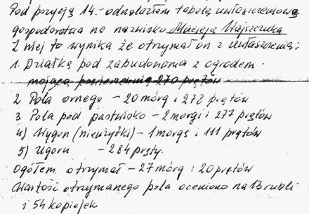
Pos. #14. Details (sizes,
kind and value) of the awarded plots.
October 22, 1912
Maciej Wajszczuk (xxxx)
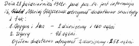
Pos. #14. Additional awarded plots from
public lands
(We are not sure about the identity of this Maciej, since Maciej
(0032), above, died in 1892. It should be noted that this award
document was signed by his son Franciszek – perhaps the land award was
still made under his father’s name).
Subsequently, documents concerning villages of
Wola Bystrzycka,
dated Febr. 19, 1864 –
1915 (Sign. #2110) and Domaszewnica,
for the years 1864 – 1915, (Sign. 1932) were reviewed – the name
Wajszczuk was not found.
Explanation
Russian measurement units, introduced under Russian rule in the
Kingdom of Poland in 1841 and used until 1915, are listed.
length - 1 sążeń = 7 feet = 84 russian inches = 2.1336 meter
surface - 1 dziesięcina = 2 400 sążeń(s) = 1.95 mórg = 1.09 hectar
see also:
Trzebieszów – details of document review in the Archives
Prepared by: Waldemar J Wajszczuk & Paweł Stefaniuk
2024
e-mail: drzewo.rodziny.wajszczuk@gmail.com
|
